Essay topics:
The map shows the development of the Chorleywood village.
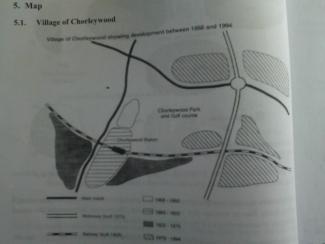
Given is a map of an village called Chorleywood illustrating its growth during the period from 1868 to 1994.
As shown in the figure, there are two main roads built between 1868 and 1883, one is from west to east and the other is from north to south. Chorleywood covered a small area next to one of the main road during this period. Beside it, meanwhile, is Chorley park and golf course. The village grew to the south along the main road between 1883 and 1922 and in 1909 a railway line was built across this area from west to east. Also Located in this area is Chorleywood Station.
With regard ...
Subscribe as testbig VIP readers and get unlimited access to essays on the top list.
Votes

Attribute Value Ideal
Score: 7.5 out of 9
Category: Very Good Excellent
No. of Grammatical Errors: 0 2
No. of Spelling Errors: 0 2
No. of Sentences: 10 10
No. of Words: 189 200
No. of Characters: 851 1000
No. of Different Words: 90 100
Fourth Root of Number of Words: 3.708 4.0
Average Word Length: 4.503 4.6
Word Length SD: 2.472 2.4
No. of Words greater than 5 chars: 49 60
No. of Words greater than 6 chars: 34 50
No. of Words greater than 7 chars: 18 40
No. of Words greater than 8 chars: 15 20
Use of Passive Voice (%): 0 0
Avg. Sentence Length: 18.9 21.0
Sentence Length SD: 8.043 7.5
Use of Discourse Markers (%): 0.3 0.12
Sentence-Text Coherence: 0.42 0.35
Sentence-Para Coherence: 0.647 0.50
Sentence-Sentence Coherence: 0.079 0.07
Number of Paragraphs: 4 4