The two maps below show road access to a city hospital in 2007 and in 2010.
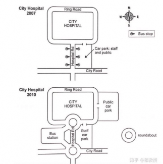
The given maps compare the road system in a city hospital in the year 2007 and 2010.
In general, there were many differences in two timelines, the most significant changes were the extentions of bus station and car park.
In 2007, the center was surrounded by Ring Road. Hospital Road was connected by Ring Road and it was gone straight to the South, stuff car park and public car park were merged in the left of Hospital Road. Other place was City Road in the South.
In 2010, there were many changes in this time: Public car park and Stuf car park were distinguished. Public car park was connected with Ring Road while stuff car park was also placed in old car park. The bus stops in Hospital Road were disappeared and replaced by a bus station in the right of Hospital Road. Other places have been preserved.
